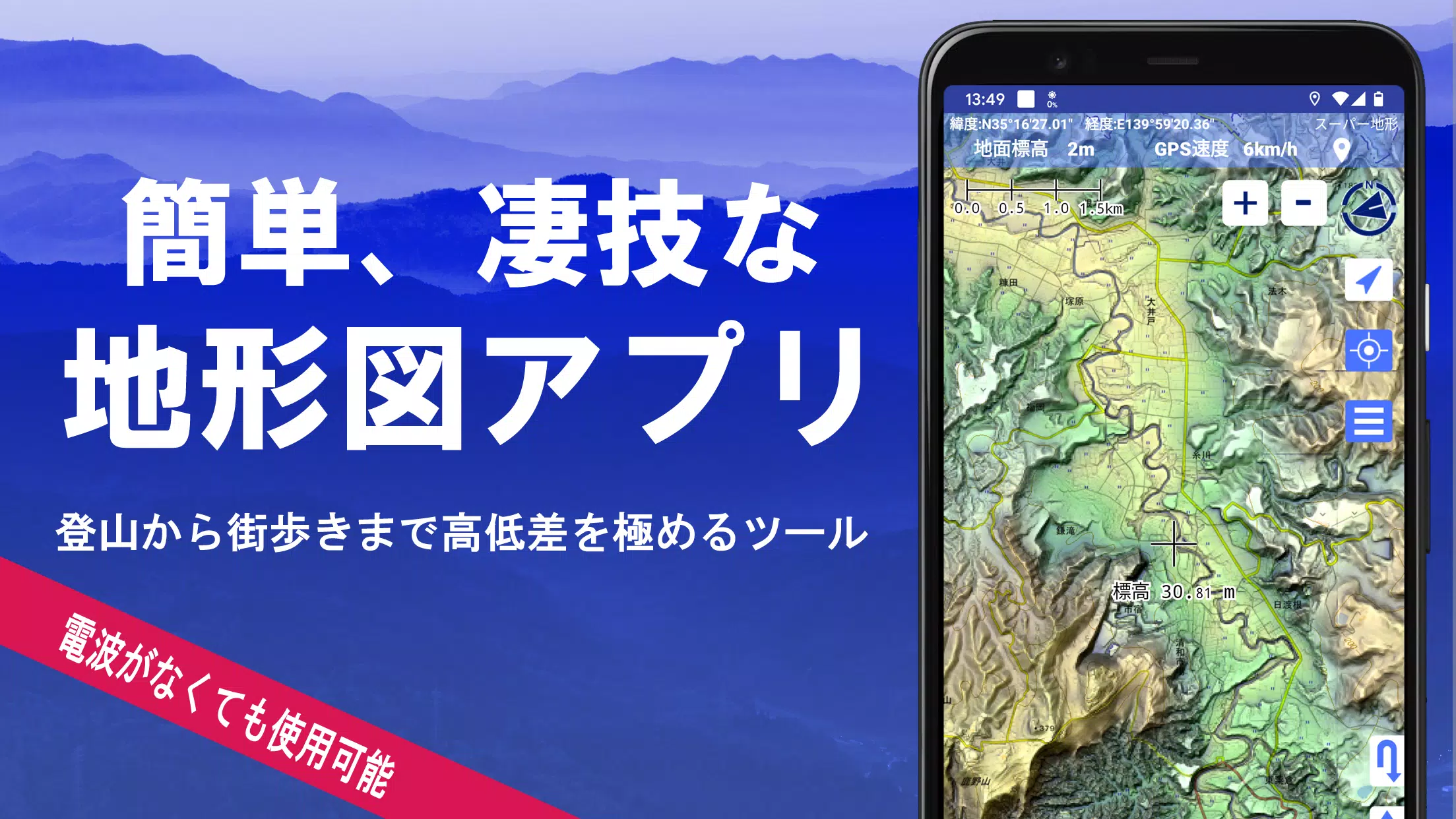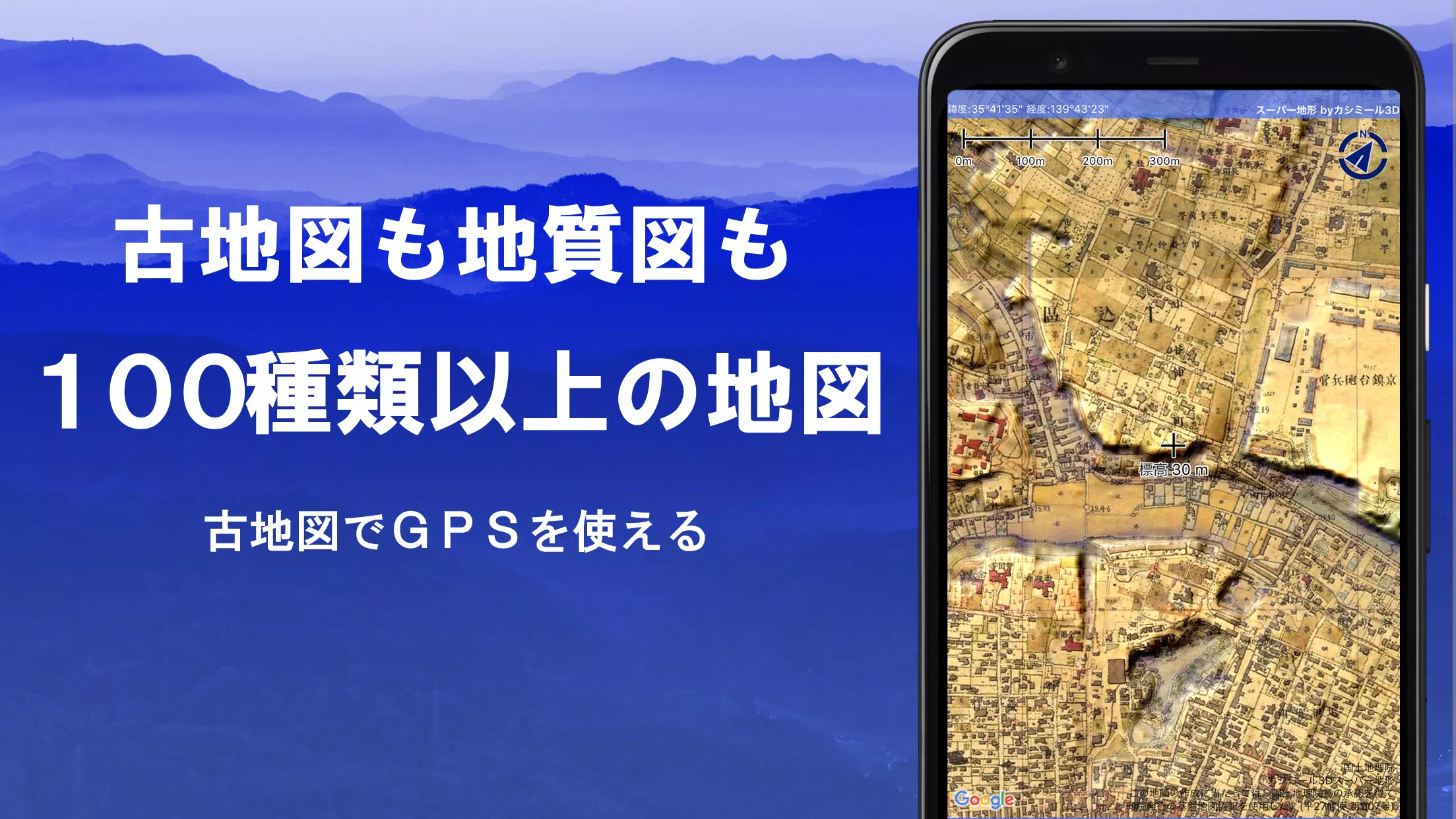
Discover a comprehensive mapping tool designed for a variety of outdoor activities, from mountain climbing to urban exploration. With over 100 types of maps at your disposal, including the highly detailed Geographical Survey Institute map, this application maximizes the potential of utilizing height differences, whether you're scaling mountains or navigating city streets.
This innovative tool was honored with the 2018 Japan Cartographic Society Award for Best Work, recognizing its outstanding contribution to cartography. The app features "super terrain data," a unique technology that emphasizes terrain details, enhancing your understanding of landscapes. You can access a wide range of maps, including those from the Geospatial Information Authority of Japan, topographic maps, geological maps, historical maps, and even prewar Ordnance Survey Department maps.
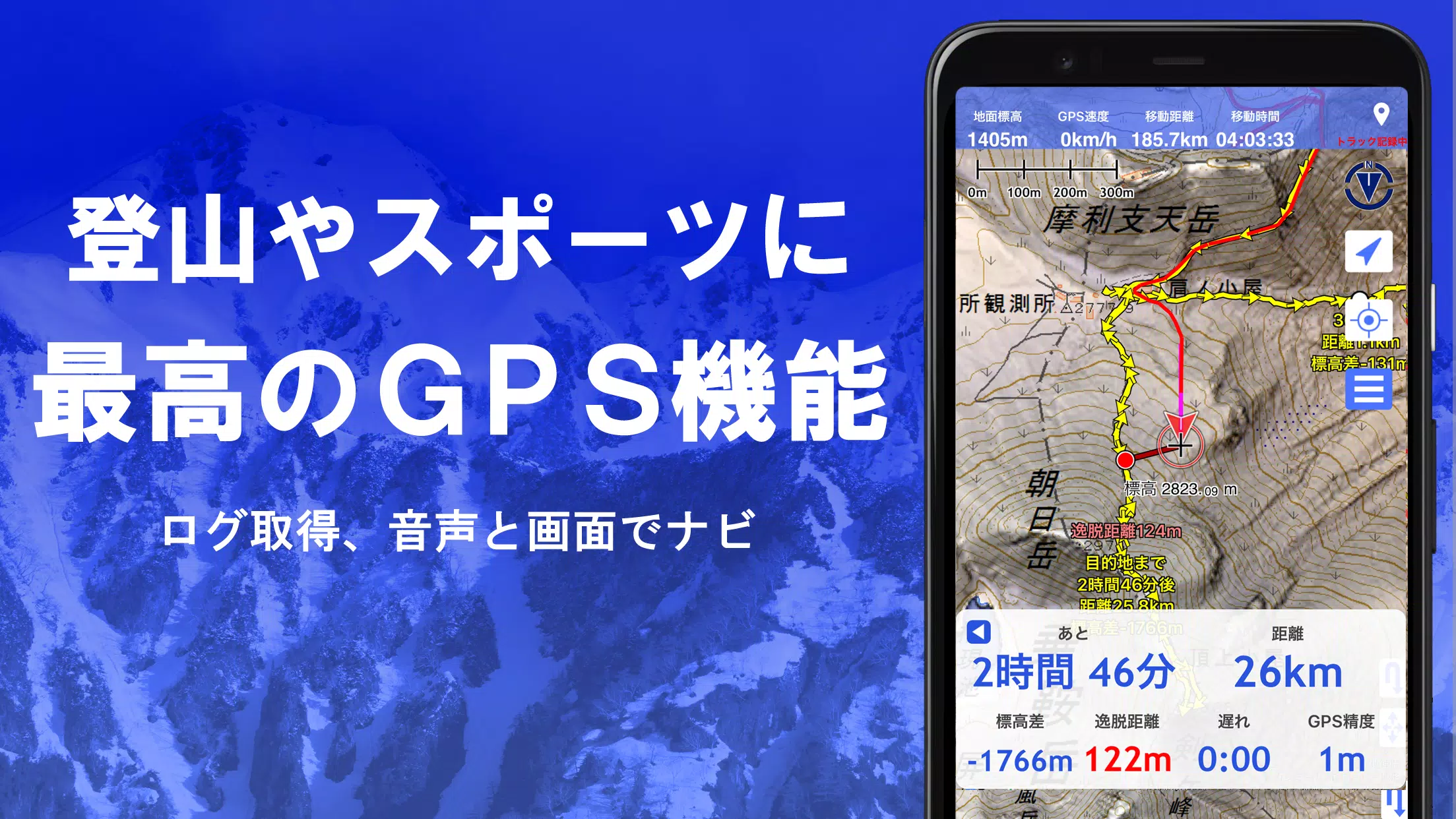
Leverage the GPS function to record tracks and trajectories, with options for GPX log input/output and editing. The app supports various outdoor activities with features like GPS navigation (with audio cues), data recording, and editing, making it an essential tool for walking around town, mountain climbing, and other outdoor pursuits.
Utilize the visibility determination function for creating cross-sectional diagrams, aiding in observations and radio communication, and even display buildings. Enjoy a 360° panoramic view function for mountain identification and display the sun, moon, and GPS points. The app's GPS capabilities, bulk map download, and map cache function ensure a seamless offline experience in areas without radio signals.
Enhance your maps by associating photos with specific points, displaying contour lines generated from elevation data, and showing MGRS grid (UTM grid). You can also read, display, and edit GIS data from GeoJSON files, draw shapes, and use the app overseas. The ability to print maps and output them as PDFs, along with a dark theme support, adds to the versatility of this tool.
1. A Wealth of Maps That Can Be Used
The app offers over 100 types of maps, including combinations of our own super topographic data and maps from the Geospatial Information Authority of Japan, as well as hazard maps. Note that aerial photographs may not be available in all locations, with the "Latest" and "around 1974" categories offering relatively wide coverage. You can use maps with super terrain data for free for 5 days after installing the app.
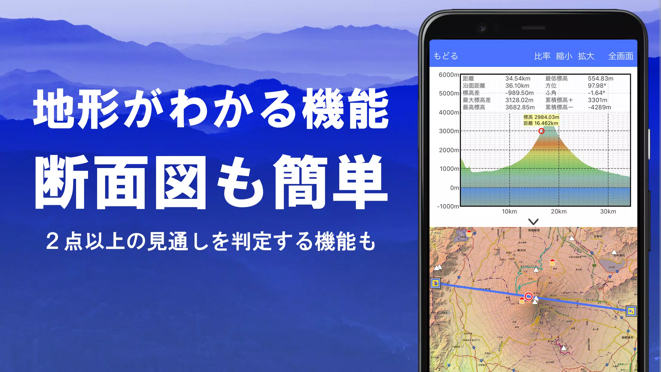
2. Creation of Cross Sections and Outlooks
Easily draw cross sections through any point on the map. The app includes a visibility judgment function from Kashmir 3D, which accounts for Earth's curvature and atmospheric differences. This feature is invaluable for route planning during climbs, checking wireless visibility, and understanding terrain. Where PLATEAU building data is available, you can create cross-sectional views including buildings.
3. Elevation Palette Function
Customize your map's appearance with the elevation palette function, allowing you to change the background color to your preferred gradient in 1cm increments.
4. Panoramic View
Enjoy panoramic observation maps that display mountain names from any point on the map. The 360-degree panorama, which integrates with your smartphone's compass, is perfect for mountain identification. You can also view the sun and moon (including moon phases), aiding in the exploration of phenomena like Diamond Fuji and Pearl Fuji. Display GPS points and even draw panoramic views of overseas mountains.
5. GPS Function
Use your smartphone's GPS to obtain location information and record tracks. The app features high-precision position measurement suitable for serious mountain climbing and outdoor activities. Display recorded tracks graphically with parameters like elevation gain, speed, time, and elapsed time. The point alarm function notifies you with voice and alarm sounds when approaching a designated point. Display photos associated with points and send the map center position to NaviCon.
6. GPS Track Summary Playback
The track playback function allows you to review your recorded tracks comprehensively. It compares the shooting times of photos stored on your smartphone and automatically displays matching photos. An icon will appear at the photo location, which you can view by tapping.
7. GPS Navigation Function
Navigate along preset tracks using the Track Navi function on your smartphone's GPS. If you deviate from the track, you'll receive a voice or alarm notification, helping prevent getting lost during climbs. The app also offers route navigation for urban exploration and point navigation for targeting specific locations.
8. GPS Data Editing Function
Manage GPS-related point, route, and track data, organizing them into folders displayed in an easy-to-read tree format. Create tracks directly on the map and import/export them in GPX format from mountain climbing sites.
9. Map Usage Outside the Service Area (Offline)
Use maps even in areas without a signal, such as during mountain climbing. The bulk download function ensures you can download all scale maps of a specified plot, showing you at a glance what has been downloaded. The cache function adds to the offline capabilities.
10. Map History Function
The app remembers your viewed locations, allowing you to return to previous spots easily.
11. Custom Map Compatible
Import and use custom maps cut out with Kashmir 3D's map cutter, displaying your own maps and scanned maps. When using the map cutter, divide each image into approximately 256 x 256 pixels and send the created kmz file to Super Terrain via email or Cloud Drive.
12. GeoJSON Compatible
Display and edit points, linestrings, and polygons from GeoJSON format files, and draw new shapes.
13. Print/PDF Output
Print any area of the map at a specified scale or create a PDF.
14. Cooperation with Other Apps
Input and output GPS data in GPX, KML, and GDB formats, allowing for data exchange with other apps and the software "Kashmir 3D" on your PC, as well as using trajectory data from mountain climbing sites.
15. Backup Function
Back up all app data (excluding cached maps) and remove it from your smartphone. You can restore data even if you delete the app or encounter a smartphone malfunction. An automatic backup feature using Google Drive ensures up-to-date backups. For detailed information, please refer to the manual.
16. About Billing Function
Some functions, such as maps using super terrain data, GPS track functions, and cross-sectional views, are available via in-app purchases. After payment, the number of search results for place name searches will increase.
- **Fees:** Annual payment of 780 yen/year.
- **Free Trial:** You can try the app for free for 5 days after first installing it. After 5 days, some features and maps will no longer be available unless you perform a purchase operation. To purchase, select [Settings] - [Purchase to remove functional restrictions] within the app.
- **Confirmation and Cancellation:** Check or cancel automatic updates from Google Play by pressing "Regular Purchase" from the menu and selecting "Super Terrain."
- **Price Revision:** Prices may be revised due to future feature enhancements, making early purchase advantageous.
17. Terms of Use
The copyright holder and developer are not responsible for the outcomes of using this application. When you start GPS for the first time, you'll be prompted to allow the use of location information services. Continuous GPS use may drain your battery, so if your device is also used for emergency communication, consider carrying a spare battery.
An easy-to-understand explanation of the navigation function is available in PDF format at: https://www.kashmir3d.com/online/superdemapp/superdem_navi.pdf
Note that with some smartphones, track recording may be interrupted or not possible due to the power-saving function forcibly closing background apps. While turning off the screen may temporarily continue recording, it is not a fundamental solution.